It seems strange to write about my time in Antarctica while I'm
sitting in the sunshine surround by trees and wearing flip flops.
A three and half hour flight from McMurdo Station on a LC-130 will bring you to the US Antarctic Program's biggest field camp: WAIS Divide. WAIS stands for the West Antarctic Ice Sheet. This is almost at the location where the ice sheet divides and flows into two different oceans. The elevation of camp sits over 6000 feet, but the ice there is over 10,000 feet thick. Wrap your mind around that and leave a comment on how that is possible.
 |
| Under that hatch at the bottom of this pit is a drill hole that goes down 10,000 feet! |
 |
| Ice crystals on the wall of the drilling arch where 10,000 feet of ice cores were removed. |
I was working with a group of scientists and grad students from the
Polenet program. We were flying out on a twin otter to GPS and seismic sensors and digging them out of the snow. These measure isostatic rebound as the glaciers melt thanks to global warming. But due to the government shutdown last year none of these sites were serviced so each of them was buried under 10 to 14 feet of snow. Each one had to be dug out and set back on the surface of the snow.
 |
| Before. |
 |
| After. Thanks congress. |
 |
| The first site was surrounded by flat white with the exception of a few volcanos in the distance. |
 |
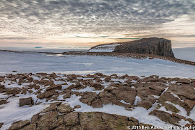
| The second site we visited was called Bear Peninsula and was one of the prettiest places I've visited in Antarctica. The flight was a few hours via twin otter from from WAIS Divide. The peninsula is along the west coast-the other side of the continent from McMurdo Station. |
 |
| Looking out toward the ocean from Bear Peninsula. |
 |
| I found living things at Bear Peninsula! |
 |
| Mountaineering with a Twin Otter. Often the plane land in a safe spot and taxi for miles to the sites...just like snow machining in an airplane. |
 |
| Mountains along the west coast of Antarctica. |


No comments:
Post a Comment