Moai on Easter Island

Moai on Easter Island
Showing posts with label Mountains. Show all posts

Tuesday, September 2, 2014

Peru, Part II

During my last week in Huaraz Lena flew down to join me.  This was her first time to South America and her 6th continent.   I was fully acclimatized, but she had just arrived from sea level so we spent a few days wandering around Huaraz and exploring a new lake called Laguna Llaca at 14,000 feet. 
 
Glacier terminating in Laguna Llaca at 14,000'
Market in Huaraz
Besides buying food and trying to figure out transport to the trailhead of Pisco, the 18,871 foot mountain that we were planning to climb, one of our main goals was to make a fake alpine club card.  The national park service of Peru--that oversees Huascaran National Park which encompasses the Cordillera Blanca mountain range--continues to come up with absolutely brilliant ideas on how to manage climbers and other visitors.  In 2011 they decided that there are only two ways that they would allow you to climb a mountain: 1. Go with a guide, or 2. Be a member of some sort of alpine club.  This decision came right after they closed one of the glaciers because they decided that it was melting too fast because people were walking on it!   A little bit of ingenuity easily combats this utter stupidity.   Don’t get me started on agencies thinking that they can close the outdoors because it is “unsafe”—that will be a rant for another time, but this one was easy to get around.  We simply made our own alpine club cards that in the end we never ended up having to show the park rangers.  But the hardest part was finding a place in Huaraz with a color printer that actually worked and then finding a place to laminate the cards.  Luckily everything came through just a few minutes before we left town for the trailhead.  Somewhere in a country where nothing seems like it will work—everything works out just fine.
 
Patterns in the glacial silt near Laguna Llaca.
Camp at Cebollapampa on the way to Pisco
Lena tentatively scoping out the route on Pisco.
Since Lena had never been mountaineering before I had to teach her a little bit about walking in crampons.  But we took one look at the horrendous glacial moraine that we had to cross to get to the lowest glacier and snow and it was an easy decision to show her walking in crampons and self arrest techniques on the dirt instead of the snow rather than walk/scramble/crawl across the moraine more than once.  We climbed down to the bottom of the lateral moraine to try out the trickiest section of the whole climb during the daylight rather than trying it navigate the vertical sand and dirt trail at 3am with headlamps. 

Looking back on Pisco basecampe with Yanapaqcha (the mountain I climbed a week earlier) and Chopi in the background.

After a few minutes of snow school on a grassy slope and a few hours of sleep we started our climb.  Once we finally got to the glacier, after getting lost in the moraine for a bit, we put crampons one and Lena took her first few steps in crampons on real snow and ice.  Just a few hours later we were on the summit of Pisco at 18,871 feet with totally clear skies and one of the best views that I’ve ever had in the Cordillera Blanca.  Sharing that climb with Lena made it even more special.   It ended up being one of my favorite climbs ever.

The view of Alpamayo and Artesonraju from the summit of Pisco.
Chopi from Pisco base camp.
We made our way back to camp, threw our gear on a donkey—I say threw because we were a few hours late coming back and our donkey driver was in a hurry to get back down.  I’ve never seen a Peruvian in such a hurry!  We caught a taxi back to Huaraz and showered and repacked so we could jump on a bus the next morning back to Lima and then on a few flights to Easter Island.

Pisco
Lena at 18,871 feet on the summit of Pisco.

Easter Island: Not that I had a list of travel destinations, but if I did Easter Island would have been on the top.  The next post or two will be about that journey.


Monday, September 1, 2014

Peru, Part I

Checking out our route on Yanapaqcha
After my first visit to Huaraz, Peru in 2009 I knew I was going to come back.  It was my first real international trip—Canada didn’t count—and I was hooked.  That was only 5 years ago and since then I’ve logged hundreds of flights and thousands of miles flying between all 7 continents. 

Yanapaqcha
Yanapaqcha Basecamp
Huaraz, Peru is a black hole much like Missoula, Montana is.  If you leave you will always come back and if you visit for a few days you will end up staying for much longer.  I’ve met so many people that have arrived in Huaraz with the intention of only staying for a very short time….and I meet them many months later and they usually had no intention of leaving.  So far it is the only place outside of the US that I could see myself living for more than just a few months.  The offer of work there keeps presenting itself, but life keeps getting in the way. 

Organizing gear for the climb.
This was my third time to Huaraz and I was hoping to be on the every other year plan, but last winter in Antarctica messed that up.  This year I was leading a group of students from the University of Montana on the Santa Cruz Trek and a six-day mountaineering course on an 18,000 foot mountain called Yanapaqcha. 


3am alpine start
Huaraz in the jumping off point for any climbing in the Cordillera Blanca range.  This is the mountain range for alpine climbing in the Peruvian Andes.  It provides convenient access to easy 18,000 foot peaks and also to some the of the hardest routes on 20,000 foot peaks on earth.  It might be the only place in the world where you could wake up to a full breakfast at a hotel and be at a 16,000 basecamp by early afternoon.
Our amazing cooks for the mountaineering course.
But this doesn’t mean you take the 8-hour bus from Lima (sea-level) to Huaraz (10,500 feet) in a day and head into the mountains right away.  So to acclimatize we did a couple of day hikes to 14,600 feet around Huaraz before heading out on the trek and mountaineering course.

One of the best things about mountaineering in Peru is that it is cheap and easy to get donkeys to carry your gear!

Just like the first time I climbed Yanapaqcha five years ago it was again in a whiteout with no views from the top.  In fact, I haven’t had a view from the top of a mountain in Peru since that first trip to the Cordillera Blanca. 
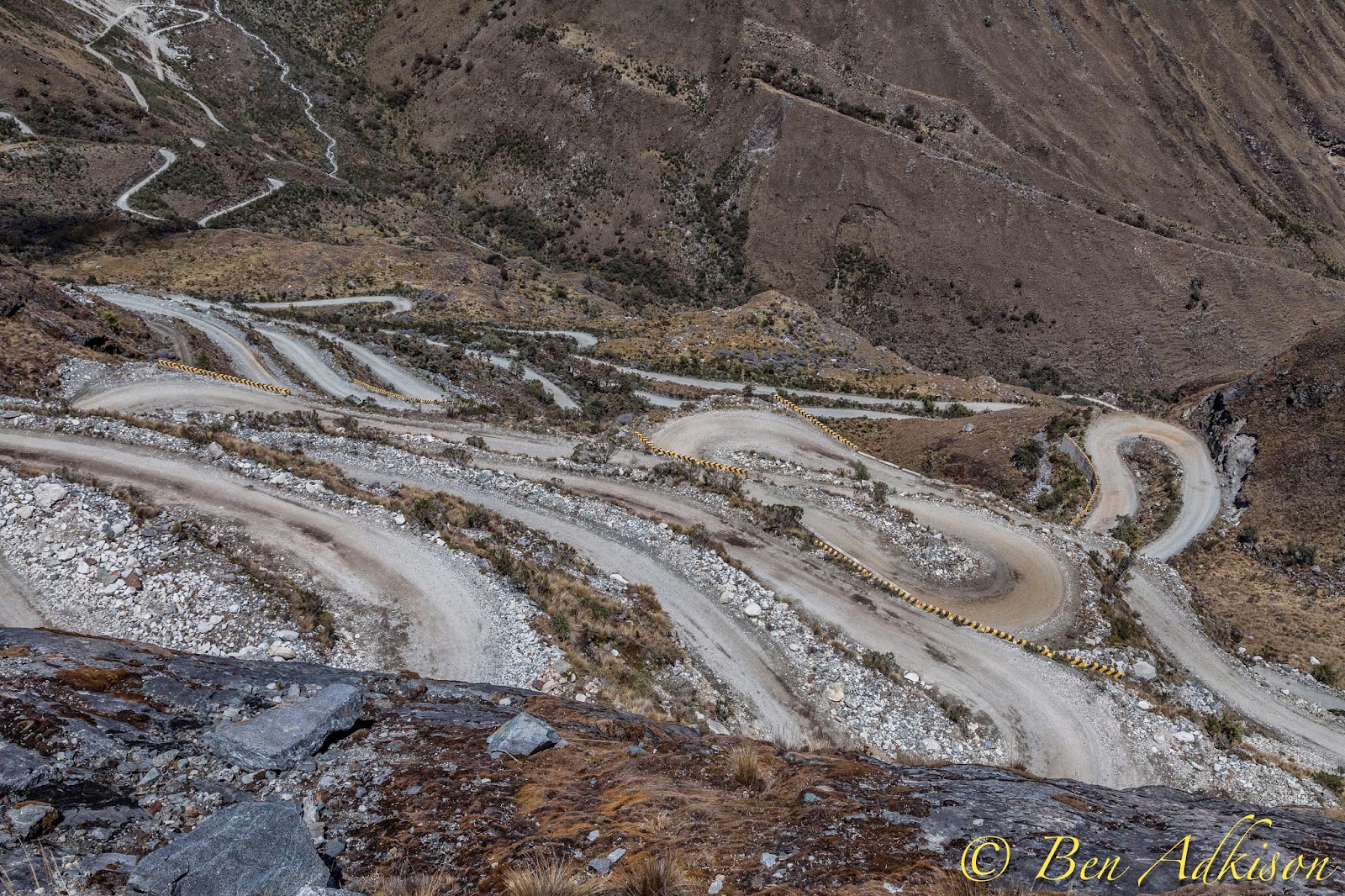
The scary, death road that we had to travel on 3 times!
It was slightly lonely after the UM students left because we’d been a solid group for two weeks exploring Peru together and attempting to navigate the Spanish language.

Saturday, August 2, 2014

Back to the Roots, Part II

When I happen to be back in Montana, every few years I get the time to head back into the Highland and Tobacco Root mountain ranges of southwest.  These are the mountains I grew up in so it is always to get back into them.
Lodgepole Pine forest floor
The Milky Way from the top of Red Mountain.
The Highlands are just south of Butte and have a  few 10,000 foot peaks in them and one small lake.  One of the peaks, Red Moutnains, is just over 10,000 and only take about 45 minutes to walk up since you can drive to almost treeline.  I decided to take some night shots and make a timeplapse video from the summit.  After a few storming days I look the first opportunity I had of a clear night.  It also happened to be the coldest night of the summer.   I froze in my summer sleeping bag huddled behind a small rock wall on the summit and some little critter decided to make a meal out of my show laces that night.  Why it didn’t go for the extra food I had in my pack that was sitting right next to my shoes I’ll never know.  But I did get some great shots out of it.  I think the milky way in Montana is brighter than it is in Antarctica.
Butte, America
Montana's Milky Way


I few days later I headed up to the Tobacco Root Mountains with a good friend that I used to work with at Lewis and Clark Caverns.  We haven’t been on a mountain together in almost exactly two years so it was great to get back into the Tobacco Roots again.

Mountain Little Sunflower in the Tobacco Root Mountains.
John near the summit of Cloudrest

These mountains are fairly overlooked, which is nice because you can easily go a whole day without seeing another person on a trail or on a mountain.  But it is nearly impossible to go a day without hearing the buzz of an ATV on one of the many mining or logging roads the cut deep into the range. 


We counted 21 mountain ranges that could be seen from the summit of Cloudrest After climbing we had to consult “The Scroll” to double check the names of some of the lakes and peaks that we’d seen in the range. “The Scroll” is a sacred collage of topo maps that cover the whole Tobacco Root Range.  It’s made up of 12 7.5-minute maps taped together and rolled up between two large wooden dowels.


Monday, September 30, 2013

A Long Year In Antarctica


My first views of Antarctica from the window of the contracted Australian Antarctic Program's Airbus A-319.
A year ago today I arrived in Antarctica and it has been a pretty crazy year.  I’ve learned a lot about myself and a lot about Antarctica.  I’ve been introduced to dynamic people and weather and ice like I never could have guessed existed.  When I arrived here I was excited to be living in one place for four and a half months since that is the longest I’ve spent in one place in years.  I never thought that a year after my initial arrive I’d still be here and have almost two months left.  I’m really excited for travel in New Zealand, Fiji, the US, South Africa and Turkey over the next six months, but I’ve also realized that I need a home to come back to.  Missoula will always be home, but I look forward to the day when I live there (or somewhere else in the mountains of the West) and I don’t get asked how many days or weeks I’m in town for.  I don’t want travel and adventure to end:  I’ll still guide mountains and come back to Antarctica, but I want a more concrete answer when I’m asked where I live. 
October 2012: Just a couple of weeks after I arrived in Antarctica I was doing some monitoring work on the sea ice and saw a few black dots in the distance.  This group of curious Emperor Penguins  slid and waddled up to us to investigate us.  It was definitely one of the coolest experiences of my life.
November 2012: Many of my field days during my first few months were spent on the sea ice of McMurdo Sound monitoring cracks and ice thickness.  The Barne Glacier is an iconic feature north of Cape Evans that I never get tired of seeing.

December 2012: The Dry Valleys Region of Antarctica is filled with bare rock and dry glaciers.  This area is known for its strong winds that flow off the polar plateau and wear away at the boulders and ridges leaving valleys full of strange rock formations.  I was fortunate enough to spend three days in the Taylor Valley on a search and rescue training trip.

January 2013:  I spent most of January at the South Pole and high on the polar plateau at one of the most remote sites on earth.  While it was a neat experience to be at the bottom of the world and at such a remote place I hope to never have to go back.

February 2013: Half of February was spent in a daze working nights while the shipping vessel was unloaded.  The sea ice had melted and McMurdo Sound was busy with a Russian icebreaker, fuel tanker, cruise ships, research vessels and finally the Ocean Giant shipping vessel with a year's worth of supplies for that station.


March 2013:  After (what we thought then was) the last flight of the summer on March 9th life slowed down quite a bit.  We all settled into our winter routine while there was still sunlight.  The month was full of amazing sunsets over the still open water and periodic ice flows.

April 2013: It is funny to look back and remember how excited we were for the sun to finally set for the winter.  I remember staying inside the Arrival Heights building soaking up the last few rays of sunlight through the window.  Four months later we did the exact same thing through the same window with the first rays of sunlight.  Each time left my eyes burning.


May 2013:  In May the dark started to encapsulate us for most of the day.  The moon and a glow on the horizon was the only glimmer in the fading light.  While the sun had been down for weeks the reality of the darkness hadn't fully set in yet.


June 2013: Although I saw my first auroras in late April the darkness of June allowed us to see them at all hours of the day.  This photo was from a late night above McMurdo viewing one of the best displays of the year.  The time lapse video from this night is on my Facebook Photography Page.


July 2013:  In the middle of winter I felt like the darkness would never end.  Now it seems so fleeting and I wish there were a few other night photos I could have taken, but in July the glow on the horizon told of the sun on its way and that was almost all I wanted at that point.


August 2013: August brought lots of change.  The sun arrived, the moon and venus and nacreous clouds put on an amazing one-night-only display and many new people arrived on station.  It was both scary and a welcome awakening.


September 2013: "Wake me up when September ends."  That has been my theme this past month.  All the 54+ hour work weeks from the last year have been catching up to me and I'm exhausted.  But the sun is up and gives everyone the needed boost.  The end is also in sight...the end of my winter job and a welcome change back to my summer job for a fantastic finish to my long season in Antarctica.

I don’t know what I’m going to feel like when I leave here.  I don’t know if I’ll remember how to shop for groceries or cook or even how to digest a real vegetable for that matter!  It’ll come back just like riding a bike I suppose.  The first few days after I arrive back in New Zealand in late November I just want to sleep and feel hydrated after living in the driest desert and eat real food and see and here animals and sounds besides just diesel engines and smell and feel plants that only exist in my mind now.  A year ago one of my coworkers told me to take care of myself because it is a long  (4-5 month) season.  That was a year ago.